Saturday, November 23, 2013

Bright Angel on the Grand Canyon


We spent the first week of November in Glendale, Arizona with my sister and her family. I had been to Arizona before long ago, but memories blur and fade with time and it seemed as new an experience for me as it was for Sam.

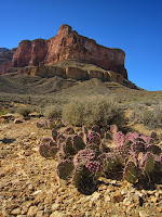
A View of the Indian Gardens from the Trail
During our time there, we made the two hour drive north to the south rim of the Grand Canyon. We planned out a day hike on the oft trekked Bright Angel Trail. The trail head is close to the visitor center and while we did not have a specific plan or destination, we intended to exercise our best judgement and get as far down the trail as we could while leaving enough time for the somewhat more arduous return trip. I would like to note that this is a most unwise way to plan hikes because inevitably you end up going further than you should and the result is that you can find yourself in quite a bit of trouble on the return trip. The Rim Trail was awash with signs detailing near misses and fatalities due to overconfident people.


In this regard, we were fortunate to have the cool fall temperatures and a well stocked backpack of supplies with each of us. With the dangers of the summer heat behind us, we would not have to face one of the most potent pitfalls that the canyon brings.

A View of the Colorado at Plateau Point
Glendale was about 25 C (77 F) for our entire trip there. I think we were caught off guard by how cold the South Rim was comparatively. The rise in elevation is significant, and by the time we reached Flagstaff the temperature was only a few degrees above freezing. We learned, to our consternation, that the weather would be similar the following morning when we planned to start our hike. This was juxtaposed by the various signs and warnings we saw along the Rim Trail warning of extreme heat and the need to take adequate water supplies.

The Grand Canyon is one of the few places on earth that evoke a surreal quality. Sam described the towering walls of the North Rim as akin to a fresco, painted by the hands of an artist as opposed to a millennial process of the Colorado leaving its mark in the sandstone.

The Bright Angel Trail includes two rest houses at Mile 1.5 and Mile 3. Further on the descent, the trail bisects the Indian Gardens, a bloom of trees and vegetation, among the arid desert soils that is fed by a small stream.

We started early in the morning at 8 am. Just like the day before, the low sun in the sky at the start the descent cast long shadows and painted contrast into the cliff walls.

I read somewhere that most photographers, especially outdoor photographers, prefer to take pictures during the early morning or late evening because the sunlight is not so harsh during these hours. The noon sun overhead can wash out colours whereas the morning and evening sun bring them out. Walking down the trail a half hour after sunrise, it was not hard to understand why.

From the Indian Gardens, you can take a path that heads roughly north out to Plateau Point where you get your first (and for us, the last) view of the Colorado River. For all the grandeur of the canyon, sometimes it is difficult to remember that it was cut mostly by the mighty Colorado River, a river that requires a 4 hour hike just to get a view of.

I realise that I am fortunate to be able to do these things. Being outside, amongst one of the grandest of spectacles is not something everyone takes or gets the opportunity to do.

The draw with these hikes is that these kinds of things never get old. You could spend a life time in here and still be learning new things every day. It lends perspective. It might have taken 17 million years to get the vista that unrolls like gigantic scroll east and west before me. My life, long or short, is comparatively brief. A setting like this is a reminder that we, as human beings, have a spectacular opportunity to contribute and to do great things. The window is brief, but if you so choose, you can be a part of something big.


We took three and a half hours to get to Plateau Point. Surprisingly, our return trip would be only four a half hours.

The Return Trip
From the Bright Angel trail head to Plateau Point is approximately 9 km (5.6 miles) and a descent of 940 m (3080 feet). The round trip took us about 8 hours walking at a relatively leisurely pace. By the time we returned to the trail head, daylight was leaving us. It was a worthwhile experience. We will return again.


Wednesday, October 9, 2013

Hualian and the Marble Gorge


It was almost a year ago that we made a trip back to Hong Kong and Taiwan. We spent almost three weeks there. The Portuguese called Taiwan Formosa, which roughly translates to the Beautiful Island. For me it was an opportunity to look back on an island, and a people, that have transformed my life in a myriad of ways. For Sam it was an opportunity to see the island for the first time.

The 380 m tunnel entrance to the 白楊 trail

白楊 Falls
The last time I set foot on Taiwan, as a LDS missionary, my travel was restricted to a specific area. In summary, I was not permitted to travel north of Xinzhu (新竹) province, south of Yunlin (雲林) province, or east of Nantou (南投) province. As a result I became very geographically familiar with many areas and towns within these boundaries while remaining generally ignorant of what lay outside. 

One such area was the east coast, and more particularly, a gorge at least partially cut by the Liwu River.

Taroko (太魯閣) lies on the east coast of Taiwan roughly two hours north of the province capital. We drove up the gorge late in the evening to a small village called Tianxiang (天祥) where we would stay for two nights. 

The gorge is cut from marble. In contrast to the Grand Canyon, which features a great deal of sandstone, the marble walls of the Taroko Gorge are a polished white.

Most of the common hiking trails are fairly brief. For the more difficult routes, you need a permit to go deeper into the park. As we were not particularly familiar with the park nor had we proper preparation for it, acquiring a permit to take some of the longer hikes (10 km or 6 miles plus) was quite out of the question.


The trails open to the general public are cut through many of the cliff walls in a tunnel network. The first and most significant walk we did started via a tunnel that is nearly 400 m in length. The trail winds along the cliff side and ends in a pair of waterfalls as well as a small tunnel featuring a "water curtain".

The trails closed to the public wind up steeper areas of the gorge. Sometimes you need chains to pull yourself up as the pathway is not particularly well cut. Usually the trails requiring permits are blocked by a gate and padlock.


Chains on the 文山步道
However, one such trail (文山步道) was either not marked properly or there was (on our part) some general confusion as to whether or not it is a trail that
required a permit.

The reasoning for the permit is due to the tumultuous geological activity that Taiwan is subject to. Several earthquakes a year lend the landscape to frequent changes including rock slides. Often, trails can be closed without warning for several weeks a year as crews have to clean up after seismic activity.

Our original plan was to only spend a part of a day here. We spent over two. There is something uniquely fascinating about this place. Taiwan can be a busy mass of humanity within the cities that I had spent so much time in four years before. Here, there was an unusual solitude that masked a landscape that could literally change every day. I feel like we just scratched the surface of what this park is.


One of the last walks we did was late in the day in a trail called the Tunnel of Nine Turns. It is not much of a trail but rather a paved walkway cut through the cliff side. It serves as a trail head to a much longer and rugged trail that requires a permit. The Nine Turns road was congested with tour buses and tourists, so we hung around later into the evening in order to avoid the throngs. It got so late that by the time we headed back to our car, nightfall was already upon us.

Flash photography to find a way back to our car

There is no light in these tunnels at night. It was pitch darkness. We had to use flash photography to make our way back to the car. One of us thought it unsettling. One of us thought it fun.


My original intention in coming here was to see it once and probably never see it again. Taiwan's east coast makes access somewhat tedious by vehicle or train. But looking back, I think it would be worthwhile to have another look and acquire permits for a deeper sojourn into Taiwan's marble canyon.


Thursday, September 12, 2013

The Lakes on Castle Mountain

Despite having spent a considerable amount of my life within sight of the Alberta Rocky Mountains, and having travelled through both Banff and Jasper National Park more times than I can remember, I still believe that these mountains are vastly under appreciated.


I think solitude is underrated in today's society. While treading a well marked trail with friends to a pair of lakes alongside Castle Mountain hardly counts as a quiet venture, there is great value in being away from the cities where the routine and tumult of day to day life coexists with us in our every moment.

Tower Lake and the larger Rockbound Lake lie near the south eastern slopes of Castle Mountain approximately 35 km (22 miles) west of the town of Banff. The trail to the lakes starts just off of the Bow Valley Parkway. It is a well worn trail that winds steadily up toward the mountain.

We met up that morning with Graham and Hayley and set out together for Banff. The four of us took the long weekend to make the quick drive to west and hike the trail. None of us had ever hiked the trail before but we expected that it would take most of the day as the round trip would be almost 18 km  (11 miles).

The trail roughly meanders in a north west direction into the arms of Castle Mountain and the ridge Helena Peak. The route climbed steadily to Tower Lake, the smaller of the two lakes and notable for the greenish hue of its waters.


Further up you climb a steep trail that switchbacks up a ridge which opens up in to a vast natural amphitheatre that houses Rockbound Lake.

Depending on your fitness level, the trail could be either quite difficult or relatively easy. There is no scrambling up to either lake, and the trail is so well marked that hiking shoes are not really necessary.


Longer hikes are good opportunities to talk and catch up. I find though that I spend a lot of my time reminiscing. This is compounded when I am with people that I have known since childhood. I find it interesting how we interact with the same friends over the years, especially as we grow as people.

Rockbound Lake is bordered by Helena Ridge on the north and the scree slopes of Castle Mountain to the west. I am told that if you hike on the eastern shore of the lake, you can scramble up the ridge and get a spectacular panoramic view. Unfortunately we started the hike later in the morning and we did not have the time to do so. Given where we were, it would take us until after 5 pm before we could return to the parking lot.

The original plan was actually to hike a much more difficult trail between Mount Cory and Mount Edith. It is getting late in the year now so I am not sure how many more opportunities we'll have to get out in 2013 but I am actually pretty excited to hit the trails again relatively soon. There is an opportunity to see a lot of things out here that in the 24 years previous of living here I have not had the eyes or interest to see.